|
Groundwater Basin Storage Tracking (GBST):
|
|
|
|
Groundswell partnered with Virginia Tech to develop the Groundwater Basin Storage Tracking (GBST) module, which allows users to rapidly (in seconds) determine changes in water supply over space and time. The intuitive Cloud interface enables users with very little training to select any beginning and ending date and time and see these changes. Traditional approaches currently require very specialized training and months of effort to generate only a single result for a specified selected date range. GBST represents the very best in the integration of IoT, sensors, GIS, Cloud based modeling, spatial statistics, and intuitive web design.
|
|
|
|
GBST can be integrated with many data sources including Federal and state water level monitoring networks, private networks, spatial statistics, models, GIS shapefiles and georeferenced grids. For instance, the entire USGS water level monitoring network (which includes thousands of sensors throughout the country’s most critical groundwater basins) is accessible to users through GBST.
|
|
|
|
GBST enables users to rapidly accomplish the following:
Determine water supply status,
Distribute alerts when key depletion thresholds are approached,
Provide supply accounting for managed aquifer recovery (MAR) projects,
Determine whether resource managers are on target to meet specific objectives based on anticipated changes in supply needs,
Enable model calibration,
Determine where additional resources should be allocated (e.g., for monitoring wells and sensors) to fill data gaps.
|
|
|
|
GBST allows for multiple aquifers to be remotely managed simultaneously within the same project. Furthermore, GBST has been integrated with the GMS modeling platform to enable spatial statistics and import of grid structures and sophisticated groundwater modeling output.
|
|
|
|
|
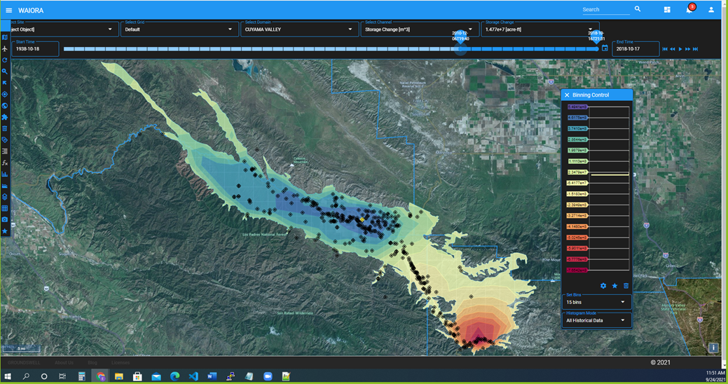
GBST Derived Change in Groundwater Storage Between 12/6/2012 and 10/16/2018. GBST was used to determine this critical information in 3 seconds. While spatial context can be observed, a total volumetric change is also reported in acre-feet, gallons or cubic meters.
|
|
|
New GBST Feature Launched - Recharge Volume Capacity
The GBST platform now allows users to estimate the amount and spatial distribution of recharge volume available for a given aquifer for any time step that water level data is available. This allows resource managers to understand changes over space and time, determine optimal locations for managed aquifer recharge, evaluate sustainability plan performance, and to determine optimal production well and monitoring well installation locations.
Below we show Recharge Volume Capacity in an aquifer at two selected time steps (1940 and 2010) and as a continuum in a time series chart ranging from 1940 through 2010. The increasing trend from 1940 through 2008 reflects groundwater depletion (and more recharge capacity).
|
|
|

|
|
|
|
Contact Groundswell for additional information.
|
|
|